Expert Surveying Services
Chimney Surveys
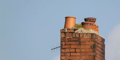
Our drone chimney surveys allow us to inspect hard-to-reach areas without the need for scaffolding or climbing. Using high-quality aerial imaging, we can check for cracks, blockages, loose brickwork, flashing damage, or general wear and tear. This method is fast, safe, and non-intrusive—perfect for older or delicate structures.
Topographic Surveys
Our topographic surveys provide accurate and detailed information about the contours and features of your property. This information is essential for construction, engineering, and land development projects.
Roof Surveys
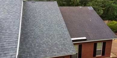
Our drone roof survey provides a safe, quick, and cost-effective way to assess the condition of your roof without the need for ladders or scaffolding. Using high-resolution aerial images and video, we can identify broken tiles, leaks, wear and tear, gutter issues, and other hidden damage.
ALTA/NSPS Land Title Surveys
ALTA/NSPS Land Title Surveys
Our ALTA/NSPS land title surveys provide a comprehensive report of your property, including boundary lines, easements, encroachments, and other important information. This is essential for commercial real estate transactions.
FEMA Elevation Certificates
ALTA/NSPS Land Title Surveys
FEMA Elevation Certificates
Our FEMA elevation certificates provide important information about the elevation of your property and can be used to determine flood insurance rates. We work with property owners and insurance companies to provide accurate and reliable certificates.
Expert Testimony
ALTA/NSPS Land Title Surveys
FEMA Elevation Certificates
Our experienced surveyors can provide expert testimony in legal proceedings related to land surveying. We have extensive knowledge of the industry and can provide valuable insights and analysis.